Table of Contents for Distance Measuring Methods
Introduction
Distance measurement is a fundamental concept that involves determining how far apart two points or objects are from each other. It plays a crucial role in various aspects of our daily lives, from everyday navigation to complex scientific research. In this introduction, we will explore the importance of distance measurement and its wide-ranging applications.
Distance Measurement Methods
- Pythagorean Theorem
- 3D Distance Formula
- Haversine Formula
- Vincenty Formulae
- GPS Coordinates
- Trilateration
- Time of Flight (ToF)
- Laser Rangefinders
- Laser Rangefinders
- Pedometers
- Wheel Odometers
- Inertial Navigation Systems (INS)
- Satellite Navigation Systems (e.g., GPS)
- Light Detection and Ranging (LiDAR)
- Aerial Surveying Techniques
1. Pythagorean Theorem
The Pythagorean Theorem, a cornerstone of geometry, provides a straightforward method for calculating distances in two-dimensional space. It’s a fundamental concept that you may have encountered in school, and its application is not limited to math class.
The formula for calculating the distance between two points in two-dimensional space is as follows:
\[ \text{Distance} = \sqrt{{(x_2 – x_1)^2 + (y_2 – y_1)^2}} \]
Where,
- (x₁, y₁) and (x₂, y₂) are the coordinates of the two points.
- (x₂ – x₁) represents the horizontal difference between the points.
- (y₂ – y₁) represents the vertical difference between the points.
- The squares of these horizontal and vertical differences are summed.
- Finally, the square root of this sum gives us the distance.
The Pythagorean Theorem is used in various fields, including:
- Architecture: Calculating diagonal measurements of structures.
- Navigation: Determining the shortest distance between two points on a map.
- Engineering: Analyzing vectors and forces.
2. Distance Formula- 3-Dimensional
While the Pythagorean Theorem is excellent for two-dimensional space, what happens when we venture into the world of three dimensions? Here’s where the Distance Formula comes into play.
The Distance Formula is like the Pythagorean Theorem but used when you want to measure how far apart things are in three dimensions instead of just two. It allows us to calculate distances in three-dimensional space. The formula is:
\[ \text{Distance} = \sqrt{ (x_2 – x_1)^2 + (y_2 – y_1)^2 + (z_2 – z_1)^2 } \]
Where,
- (x₁, y₁, z₁) and (x₂, y₂, z₂) are the coordinates of the two points.
- (x₂ – x₁), (y₂ – y₁), and (z₂ – z₁) represent the differences along the x, y, and z axes.
- We square and sum these differences, then take the square root to find the distance.
The Distance Formula is indispensable in scenarios where three-dimensional measurements are crucial, such as:
- 3D modelling and animation: Calculating the distance between points in a 3D space.
- Astronomy: Measuring the vast distances between celestial bodies.
- Engineering: Analyzing spatial relationships in complex structures.
3. Haversine Formula
When we step outside Earth’s flat maps and embrace its spherical nature, the Haversine Formula comes to our rescue. It calculates the great-circle distance between two points on the Earth’s surface.
The Haversine Formula is specifically designed for calculating distances on a sphere and is expressed as:
\[\text{Distance} = 2r \cdot \arcsin\left(\sqrt{\sin^2\left(\frac{\phi_2 – \phi_1}{2}\right) + \cos(\phi_1) \cdot \cos(\phi_2) \cdot \sin^2\left(\frac{\lambda_2 – \lambda_1}{2}\right)}\right)\]
Where,
- φ₁ and φ₂ are the latitudes of the two points.
- λ₁ and λ₂ are the longitudes of the two points.
- r represents the radius of the Earth
The Haversine Formula finds applications in:
- Navigation: Determining the shortest path between two points on Earth.
- Aviation: Calculating great-circle distances for flight planning.
- Geocaching: Precisely locating hidden treasures on a spherical Earth.
4. Vincenty Formulae
For scenarios where a higher degree of accuracy is required, such as geodesy and geodetic surveys, the Vincenty Formulae come into play. These formulas account for the ellipsoidal shape of the Earth, acknowledging that our planet isn’t a perfect sphere. The Vincenty Formulae are a set of complex, iterative calculations used to determine distances between two points on an ellipsoid accurately. These formulas involve several equations, including those for the latitude and longitude.
The Vincenty Formulae are essential in fields such as:
- Geodesy: Precise measurement and representation of the Earth’s shape.
- Surveying: Accurate determination of distances on the Earth’s surface.
- GPS and Satellite Navigation: Ensuring precise location data.
5. GPS Coordinates
In the age of global positioning, GPS coordinates have become an integral part of our lives. These coordinates help us pinpoint our location and navigate with ease. The distance between two GPS coordinates can be calculated using either the Haversine Formula or the Vincenty Formulae, depending on the desired level of accuracy. These formulas take into account the curvature of the Earth and provide precise distance calculations.
GPS coordinates are used extensively in:
- Navigation: Finding the quickest route from point A to point B.
- Location-Based Services: Locating nearby restaurants, businesses, and landmarks.
- Geocaching: Pursuing outdoor treasure hunts using GPS coordinates.
6. Trilateration
Ever wondered how your GPS receiver can pinpoint your location accurately? The answer lies in trilateration, a method that calculates distances to three known reference points. Trilateration operates by measuring the time it takes for signals from at least three satellites to reach your GPS receiver. By understanding how fast light travels, the receiver can figure out how far each satellite is. When these distances intersect, your exact location is determined.
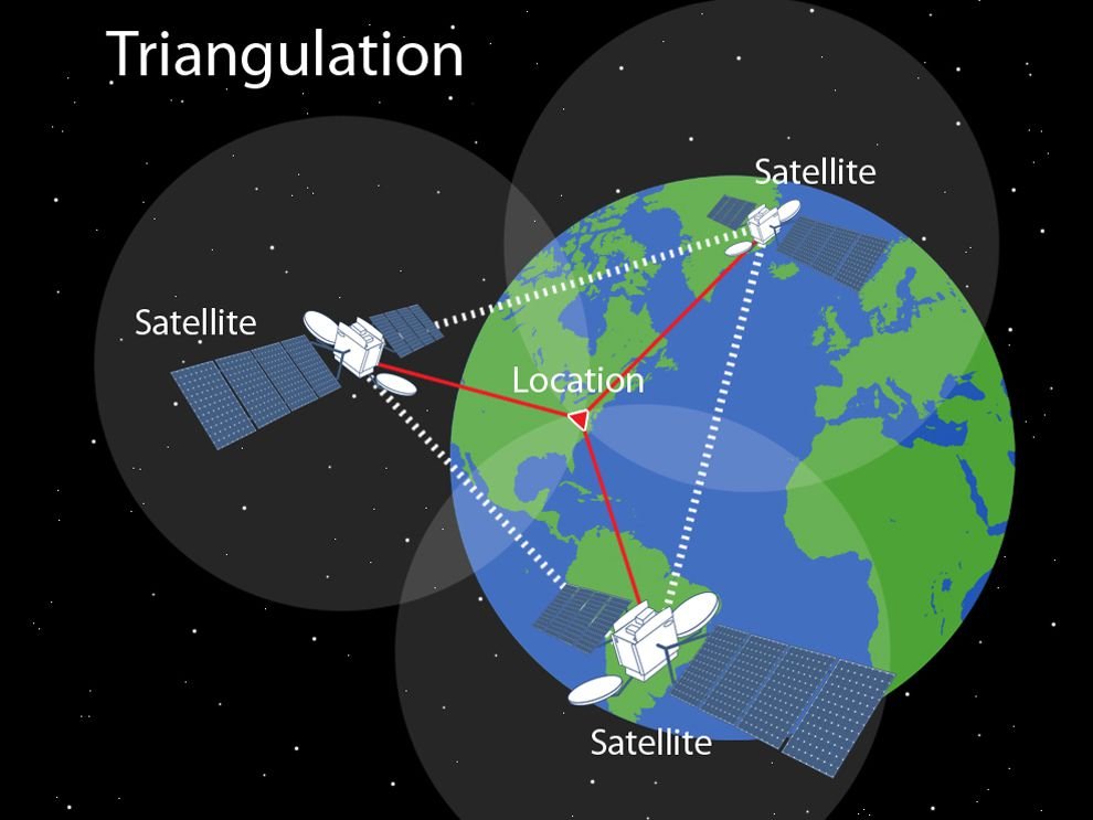
Trilateration is the backbone of global positioning systems, making it possible to:
- Navigate with precision, whether on the road or at sea.
- Locate lost or stolen devices using Wi-Fi and cell towers.
- Geolocate assets and track their movements.
7. Time of Flight (ToF)
ToF is a method that measures the time it takes for a signal, whether it’s light or sound, to travel to an object and bounce back. The speed of the signal is key to calculating the distance.
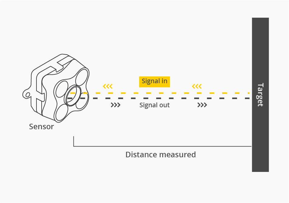
The formula for calculating distance using ToF is simple:
\[ \text{Distance} = \frac{\text{Speed of Signal} \times \text{Time}}{2} \]
In this equation:
- Speed of Signal: The speed at which the signal (e.g., light or sound) travels.
- Time: The time it takes for the signal to bounce back.
ToF is used in various scenarios, including:
- Ultrasonic sensors in autonomous vehicles, ensuring obstacle detection.
- LiDAR technology for creating high-resolution 3D maps.
- Laser rangefinders in surveying, construction, and golf.
8. Laser Rangefinders
Laser rangefinders are instrumental in applications where precision is paramount. These devices emit a laser beam and measure the time it takes for the beam to return, exploiting the constant speed of light.
\[ \text{Distance} = \frac{\text{Speed of Light} \times \text{Time}}{2} \]
In this calculation:
- Speed of Light: The speed at which light travels in a vacuum.
- Time: The time it takes for the laser beam to return.
Laser rangefinders are used in:
- Surveying and construction for precise distance measurements.
- Golf for determining the distance to the flag.
- Forestry for measuring tree heights and forest stands.
9. Ultrasonic Ranging
Ultrasonic ranging employs sound waves to measure distance, making it valuable in applications where precision is essential. Ultrasonic sensors emit sound waves, and by measuring the time it takes for these waves to bounce back, the device calculates distance. The speed of sound in air is crucial for these calculations.
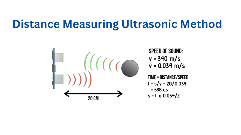
Ultrasonic ranging is Used in:
- Automotive parking assist systems to prevent collisions.
- Robotics for obstacle detection and safe navigation.
- Industrial automation for accurate positioning.
10. Pedometers
Pedometers have become ubiquitous in the fitness world. They provide a simple way to calculate the distance walked or run by counting steps and multiplying by the average step length.
Distance = Number of Steps × Average Step Length
In this calculation:
- Number of Steps: The count of your steps recorded by the pedometer.
- Average Step Length: The approximate length of your steps.
Pedometers are popular in:
- Fitness tracking devices for monitoring daily activity.
- Health and wellness apps to encourage physical activity.
- Personal fitness goals for motivation and progress tracking.
11. Wheel Odometers
Wheel odometers, commonly found in vehicles, calculate distance by counting the number of wheel rotations and multiplying by the wheel’s circumference.
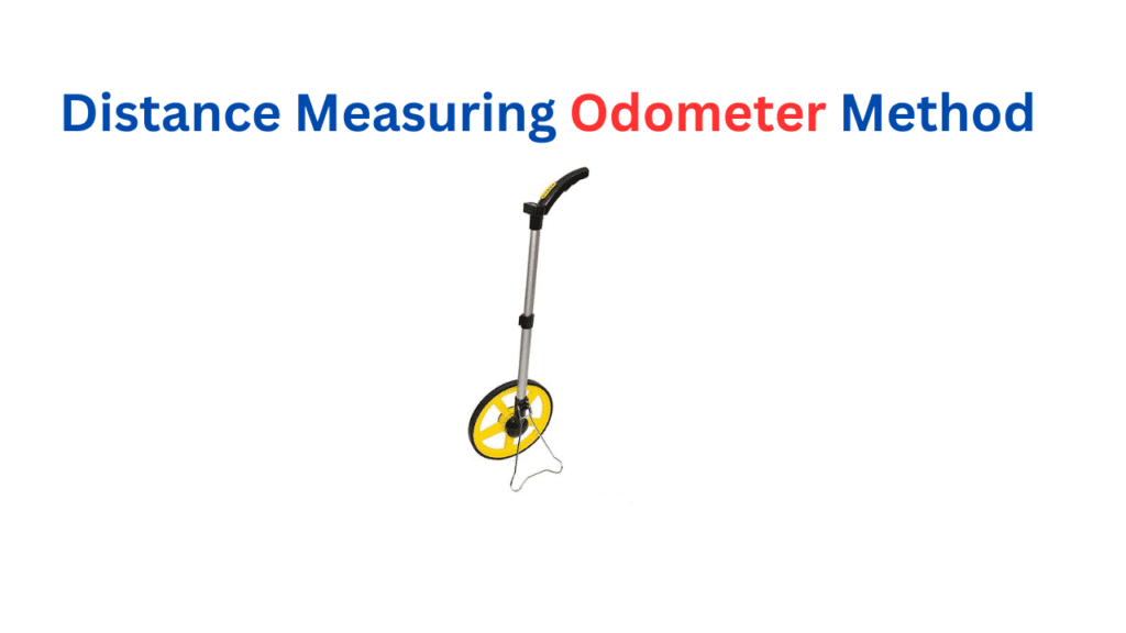
Distance = Number of Wheel Rotations × Wheel Circumference
In this calculation:
- Number of Wheel Rotations: Counted by the wheel odometer as you drive.
- Wheel Circumference: The distance around the wheel’s outer edge.
Wheel odometers are used in:
- Vehicles for tracking mileage and fuel efficiency.
- Sports tracking devices for cyclists and runners.
- Measuring distance in industrial settings.
12. Inertial Navigation Systems
Inertial Navigation Systems (INS) are a class of navigation systems that calculate distance by continuously measuring acceleration and changes in velocity. INS operates by tracking changes in velocity over time. By integrating these changes, it determines the distance traveled. This technology is used in aircraft, spacecraft, and even smartphones.
INS is used in:
- Aviation for precise aircraft navigation.
- Space exploration for guidance and orientation.
- Personal devices for location tracking and augmented reality.
13. Satellite Navigation Systems – The Global GPS Network
The advent of satellite navigation systems, with the Global Positioning System (GPS) as a prime example, has revolutionized how we calculate distance and navigate the world. GPS receivers calculate distances by measuring the time it takes for signals to travel from multiple satellites. These distances are used to triangulate your exact location on Earth’s surface.
Satellite navigation systems are used to:
- Personal navigation devices for driving directions.
- Emergency services for locating distress calls.
- Precise timing and synchronization in various industries.
14. LiDAR
LiDAR (Light Detection and Ranging) is a remote sensing technology that calculates distances by measuring the time it takes for laser pulses to bounce off objects and return. LiDAR systems emit laser pulses and record the time it takes for them to reflect back. By knowing the speed of light, they accurately calculate distances. LiDAR is used in various fields, including autonomous vehicles and archaeology.
LiDAR technology is used in:
- Autonomous vehicles for obstacle detection and navigation.
- Environmental monitoring for terrain mapping and forestry.
- Archaeology for the discovery and preservation of historical sites.
15. Aerial Surveying Techniques
Aerial surveying techniques involve capturing the Earth’s surface from above, whether through aerial photography or satellite imagery. These techniques are vital for measuring distances and creating detailed maps. Aerial surveying relies on high-resolution imagery and photogrammetry to measure distances. It plays a crucial role in cartography, land use planning, and environmental studies.
Aerial surveying techniques are used in:
- Creating detailed topographic maps.
- Environmental conservation for monitoring changes.
- Urban planning for infrastructure development
Conclusion
The world of distance measurement is vast and diverse, encompassing a multitude of methods and formulas, each tailored to specific needs and scenarios. Whether you’re navigating the open road, exploring the cosmos, or designing the future, understanding how to calculate distances accurately empowers you to unravel the mysteries of space, time, and the physical world around us.
Get ready to embark on your distance-measuring journey, armed with the knowledge of these versatile methods and formulas. After all, in a world where every inch matters, precision is key.
FAQs
Q1: Can I use the Pythagorean Theorem for finding the distance between two cities on a map?
Yes, you can use the Pythagorean Theorem for approximate distances on flat maps, but for more accurate results over long distances, consider using the Haversine Formula for Earth’s curvature.
Q2: What’s the difference between the Haversine and Vincenty Formulae for Earth’s surface distance calculations?
The Haversine Formula is a simpler method suitable for most applications, while the Vincenty Formulae are more complex but offer higher accuracy, especially for long distances.
Q3: How does GPS calculate the distance between a device and satellites?
GPS receivers calculate distances by measuring the time it takes for signals to travel from satellites. The distances are then used to determine the device’s location.
Q4: Are laser rangefinders and LiDAR the same thing?
No, laser rangefinders are handheld devices that measure distances to specific objects, while LiDAR is a remote sensing technology that scans and maps entire areas with laser pulses.
Q5: Can I use pedometers to measure the distance I run during a marathon?
Pedometers are designed for step counting and may not provide accurate distance measurements for running. Consider using a GPS watch or specialized running app for precise results.
